|
travel@pangolin.liNamibia 2003
|
 |
 |
www.pangolin.li
home Travel
directory Travel
directory Namibia
2003 Main
Part 1 Etosha
Part 1a
Animals Part 2
Otjitotongwe Part 3 Highlands Part 4 Van Zyl's
P. Part 5 Marienfluss Part 6 Kaokoveld
Part 7 Damaraland Part 8
Twyfelfontein Part 9 Namib Part 10 Wolwedans Part 11 Gamsberg Panorama pics Namibia '03 Gallery
Namibia
2003 Main
Part 1 Etosha
Part 1a
Animals Part 2
Otjitotongwe Part 3 Highlands Part 4 Van Zyl's
P. Part 5 Marienfluss Part 6 Kaokoveld
Part 7 Damaraland Part 8
Twyfelfontein Part 9 Namib Part 10 Wolwedans Part 11 Gamsberg Panorama pics Namibia '03 Gallery |
|
contact last updated: 30-Jul-2005 Text/pictures subject to copyright by pangolin.li |
 |

 |
||||||||||||||||
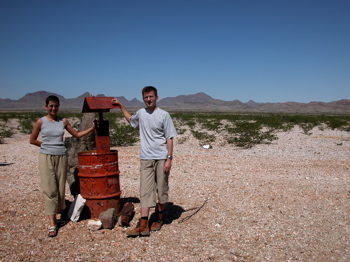
Part 6 - Red Drum, Hartmann's Valley and "Kaoko Camp"Travel detailsDriving southwards from Camp Syncro (km 240 from Opuwo) up Marienflusstal towards Sesfontein leads first to Rooidrum (Red Drum, km 310) - a well-known waypoint consisting of a red drum. The track to the left leads directly to Otjihaa/Orupembe; we took the right one to Hartmann's valley (and from there South to Orupembe). At km 322, a waterpump is seen, and at km 327 follows Blue Drum. From there, we wanted to go to Hartmann's Valley.The Shell Map we used was not accurate enough in this region, and the tracks are somewhat blurred, a fact we noticed only after taking a first wrong turn right towards the Hartmann's mountains. Followed by another wrong turn south-west... The Shell map shows a 8*8*8 km triangle in this region, and we took the wrong way from Blue Drum (km 327) to the Southern tip of the triangle (km 337) to the correct Western tip (km 343) The correct way from Blue Drum would be West towards coordinates S17 46 22.9 E12 18 30.7 (which is the next junction towards Hartmann's Valley). We then drove approx. 32 km into Hartmann's Valley (km 375), but there decided to split up. Micha and Susanita proceeded down to Kunene, JJ and myself drove out of Hartmann's Valley again and camped in the wild near the Southern Tip of the Triangle - "Kaoko Camp" (km 414). The next day, we drove on via Orupembe to Purros. Also for this part of the trip, we used GPS coordinates from Wouter Brand, and The Shell Map of Kaokoland (Kunene Region), 1:625 000 (issued 1996). Check also the main page for more info on maps and books about Namibia. Contact me if you'd like to get our GPS data of this trip. And do check out our Namibia '03 photo Gallery. Marienflusstal to Hartmann's Valley
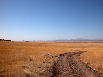
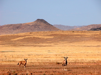
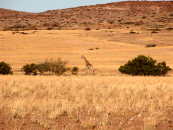
From Red Drum we went on towards Blue Drum (S17 47 26.9 E12 23 17.3) - again just a blue drum, but this one didn't make it to the maps. In short: we messed up navigation, but in the end we landed at the "start" of Hartmann's Valley, with another red drum. Top of page Hartmann's ValleyHartmann's Valley is even more arid than Marienflusstal. The sand is more golden than red, and combined with the dry grass this gives the whole valley an aura of solid gold. Beautiful against the blue sky. There are endless meadows of golden grass bound by the dark rock of Hartmann's Mountains. And they were empty. No trace of mankind except for the tracks (too many parallel). But we've seen many gemsbok (Oryx), even two funny young ones. I read that they do not pee but recycle the water in their urine, and they can actively raise their body temperature. No wonder they are the only living souls we've seen in this dry land!
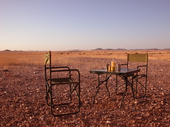
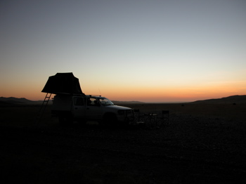
At km 375 (S17 31 02.2 E12 16 01.5), JJ and myself decided to turn back to camp outside of the valley, whereas Micha and Susanita drove on to the Hartmann's Valley Campsite near Kunene. Top of page Kaoko CampWe built our camp South of the Engo rivier, well out of Hartmann's Valley (camping in the valley is forbidden), at km 414 (S17 49 25.1 E12 21 04.7). There's nothing there. Well: there are stones, dry grass and a stunningly beautiful empty landscape. We were just in time to start camp, carefully build a stove out of reach of the wind and dry grass, and then enjoy our usual Gin & Tonic sundowner. The sunset that followed is No. 1 or No. 2 ever, in my living live. Probably because it felt like there is nothing else between the sun and us except for some distant hills and a hint of the Skeleton Coast fog. Probably also because the colours they displayed for us where better than all photoshopped sunsets combined.
We slept in absolute quietness covered by about a billion of stars, with no human soul except us two within the next 50 km. I raised the flap of the tent well before sunrise - just in time to see a lone bat-eared fox strolling around our car. Soon after came a lone gemsbok, and this was it for a while.
Top of page Go to:
|
||||||||||||||||
 |